The purpose of last Sunday’s race was to try and gauge whether I should register for the Muskoka half-ironman in September or not. Looks like I’m not going to be registering for this year. I could definitely finish it, but based on the Muskoka long course race on Sunday I don’t think I’d be able to compete at the level I want to for it to be worth it.
The swim went well, but on the bike I started running into mechanical issues, and the run walk was a complete waste. Here’s the full report and some pics.
On the bright side I’ve got some juicy GPS data from the swim.

The yellow line is the approximated actual course. My turns were actually fairly close to the buoys, so it should be fairly accurate. Google Earth shows this as being 2021 metres, which is pretty close to the reported distance of 2000 metres.
The red line is my actual GPS track. My Edge was in my swim cap (it’s pretty big), located on the back of my head. It was a cloudless day, so it looks like it actually got a pretty accurate reading. It reads as being 2170 metres. It’s always a bit high.
Inside the red line is a white line I drew in Google Earth that averages out my GPS path. Since the GPS goes slightly underwater every stroke it really messes up the paths. The line I drew should be very close to my actual path. There are a couple parts where I remember making sharp navigation errors that even show up in there. That reads as 2044 metres.
The odd little line is the 22 metre green one. That’s the distance of the furthest point from where I diverged from the optimal line. I’m not sure if it makes sense after you look at the numbers.
2044m – (actual swam) subtract
2021m – (actual course) equals
23m extra swimming due to bad navigation
But if you look at my path, I went 22m off-course before the first turn, and then almost as much again by the second turn. Hrm. That doesn’t really seem to make sense.
I measured from the start point to the first buoy only. Actual distance is 512m, and my averaged swim path is 524m, for a difference of 12m. How could I go 22m off-course and still only have swam 12m more than someone who went straight? I actually had to draw this out and measure.
Oh jeez. Pythagorean Theorum. Grade nine math. a^2 + b^2 = c^2.
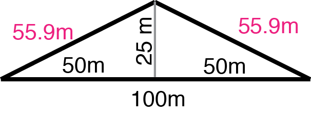
So if there was a 100m straight line course and you went 25m off-course, then you’re going to travel 111.8m. So I guess that all makes sense now.
If I would have had perfect navigation my time in the swim would have dropped from 48:18 to 47:45. That’s 33 seconds, or about a 1% improvement. Theoretically at least. In reality if I would have been navigating better I would have been closer to the pack and had a few more options for drafting.
At least now I know that going off course isn’t necessarily that bad, as long as you keep your lines straight. Zig zagging will just compound the problem. But if you’re a few metres out from where you want to be, don’t try to compensate for it and try to head toward the middle of the course because you’re probably going to overshoot.
Keep looking ahead!